Definition
A floodplain is the relatively flat area of land bordering a river channel that is periodically submerged when the river overflows its banks. Floodplains are built directly by this flooding process: each time the river spills over, it deposits some of the sediment it was carrying across the adjacent land, gradually building up fertile layers of soil over time. The width and extent of a floodplain depends on the size of the river, the steepness of the surrounding terrain, and how frequently significant flooding occurs.
How It Forms
Floodplains form through a repeating cycle of overflow and deposition that plays out over many individual flood events.
- Heavy rainfall or snowmelt increases river flow.
Seasonal rain, storms, or melting snow upstream increase the volume of water entering the river faster than its channel can carry it away.
- The river overflows its banks.
Once the channel reaches capacity, excess water spreads out across the adjoining low-lying land, slowing down significantly as it does so.
- Sediment drops out of the slowing water.
As floodwater loses speed spreading across the floodplain, it can no longer carry as much sediment, and it deposits a thin layer of silt and clay across the inundated area.
- The river eventually recedes.
Once the flood passes, water drains back toward the main channel or evaporates, leaving the freshly deposited sediment layer behind on the floodplain surface.
- Repeated floods build up the land over time.
Each subsequent flood adds another thin layer of sediment, and over many cycles this builds a floodplain's characteristic flat, layered, fertile soil.
Formation Timescale
Individual flood events that shape a floodplain typically last from days to a few weeks, but the floodplain as a sustained landform is built up over decades to centuries of repeated flooding. The overall extent and shape of a floodplain can also shift over longer periods, sometimes centuries, as a river gradually changes its course across the flat terrain it has built, abandoning some areas while actively flooding others. Because flood frequency and intensity vary by river and by year, there is no single number that describes how long it takes to create a "typical" floodplain.
Main Characteristics
- Low, flat topography: floodplains sit only slightly above the river's normal water level, which is exactly why they are vulnerable to flooding.
- Layered sediment deposits: repeated floods build up visibly layered soil, often alternating in texture depending on flood intensity.
- High soil fertility: regularly replenished sediment makes floodplain soil some of the most productive agricultural land in many regions.
- Natural levees: coarser sediment often builds up immediately along the riverbank, forming slightly raised ridges compared to the floodplain further out.
- Meanders and oxbow lakes: many floodplains show evidence of the river's shifting course over time, including abandoned curved channel segments.
Materials and Structures Involved
Floodplain soil is typically composed of fine-grained alluvium — silt and clay deposited during the slower-moving later stages of a flood — often with coarser sand closer to the active channel where floodwater still moves relatively quickly. Over many flood cycles, these deposits build up into a thick, usually horizontally layered sequence that can preserve a long-term record of past flood events, river course changes, and sometimes even past climate conditions. Researchers can sometimes read this layered record much like tree rings, using the thickness and composition of individual flood deposits to reconstruct how flood frequency and intensity have changed over time in a given river system.
Climates and Environments
Floodplains occur wherever a river periodically exceeds its channel capacity, which happens in virtually every climate, though the timing and cause of flooding varies: seasonal monsoon rains drive flooding along rivers like the Mekong, while snowmelt plays a larger role for many rivers in temperate and mountainous regions. Because of their fertile soil and reliable water access, floodplains have supported human agriculture and settlement for thousands of years, even though this same proximity to the river also creates ongoing flood risk. In regions with pronounced wet and dry seasons, floodplain ecosystems are often specifically adapted to this predictable cycle of inundation and drying, rather than to flooding as an occasional disruption.
Real Examples
The Amazon floodplain in South America undergoes dramatic seasonal flooding that can raise water levels by many meters, supporting a uniquely adapted floodplain forest ecosystem known locally as várzea. The Nile floodplain in Egypt supported one of the world's earliest major agricultural civilizations, reliably replenished by annual flooding before the construction of modern dams altered that natural cycle. The Mekong floodplain in Southeast Asia is shaped by seasonal monsoon-driven flooding that remains central to regional rice agriculture. The Mississippi floodplain in North America has been extensively modified with levees and flood-control structures to protect nearby development.
How It Continues to Change
Floodplains remain active, changing landscapes wherever natural flooding still occurs, continuing to receive new sediment and occasionally shifting as rivers change course across them. In many regions, however, levees, dams, and other flood-control infrastructure have significantly altered natural floodplain processes, in some cases starving floodplains of the sediment that once replenished them and increasing the severity of flooding elsewhere when it does occur. Restoring at least some natural floodplain function has become an increasing focus of river management in several countries.
Some restoration projects deliberately reconnect a river to sections of its historic floodplain by removing or setting back levees, allowing controlled flooding to resume in areas where it can reduce downstream risk and rebuild wetland habitat. Other regions have focused instead on upgrading levees and building additional flood-control reservoirs to protect developed floodplain land. Which approach is used in a given river system usually reflects a balance between the economic value of existing development and the long-term benefits of restoring more natural flood behavior.
How It Differs From Similar Formations
Floodplains are closely related to river deltas, but a floodplain is the land that floods along a river's course inland, while a delta specifically forms where a river deposits sediment as it meets standing water. They also overlap with wetlands, since many floodplains support wetland conditions during and after flooding, though not all floodplain land remains saturated year-round the way a true wetland does. Compared to a broader plain, a floodplain is specifically tied to an active river's flooding behavior rather than being a general low-relief landform.
Common Misconceptions
Misconception: A floodplain only matters during an actual flood.
Reality: Floodplain soil and fertility are shaped continuously by the long-term accumulation of flood deposits, making the floodplain significant even between flood events.
Misconception: Building levees eliminates flood risk permanently.
Reality: Levees can reduce flooding in a protected area but often increase flood severity downstream or during floods that exceed the levee's design capacity.
Misconception: Floodplain boundaries never change.
Reality: As rivers shift course over time, the active floodplain can move, leaving some older floodplain areas higher and drier while new areas become subject to flooding.
Key Terms
- Floodplain — The flat land bordering a river that is periodically covered by water during floods and built up by deposited sediment.
- Alluvium — Loose sediment — clay, silt, sand, or gravel — deposited by flowing water, typically in riverbeds, floodplains, and deltas.
- Levee — A raised ridge of sediment along a riverbank, built naturally during floods or constructed artificially to contain water.
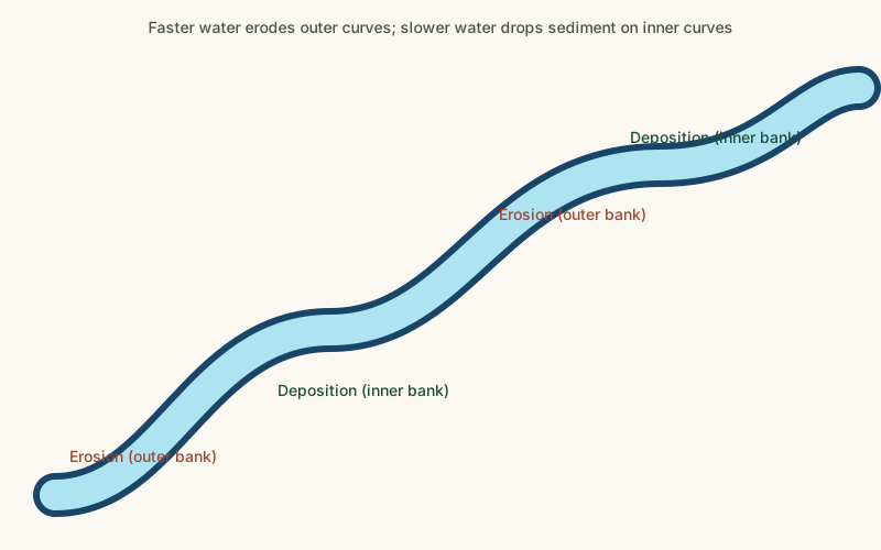
- Meander — A winding curve in a river channel, formed as flowing water erodes the outer bank and deposits sediment on the inner bank.
- Oxbow Lake — A curved lake formed when a river meander is cut off from the main channel and left isolated.
- Deposition — The process by which sediment carried by wind, water, or ice is laid down and accumulates in a new location.