Definition
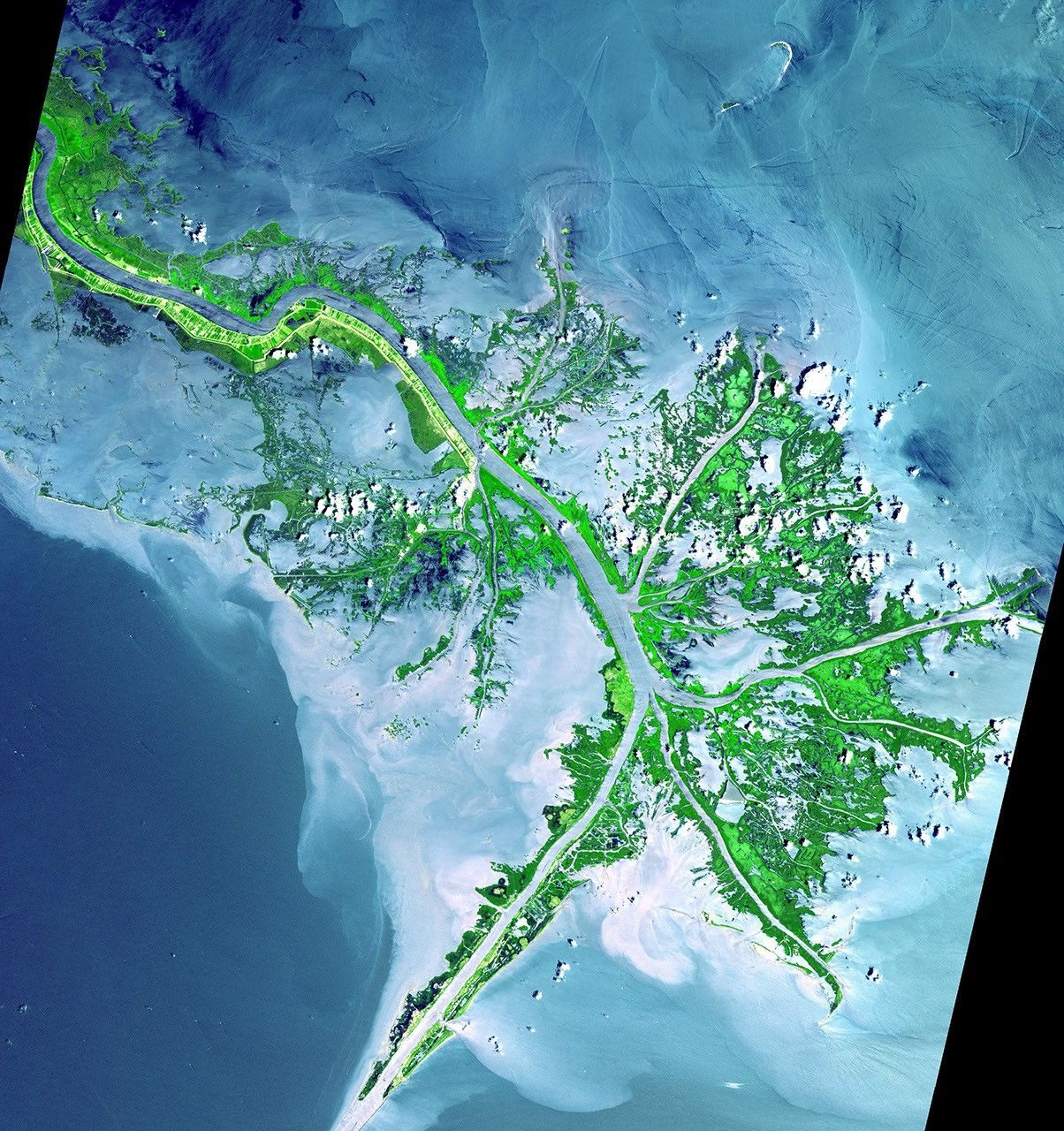
A river delta is a landform built where a river deposits sediment as it enters a body of standing water — typically an ocean, sea, or lake — and loses the energy it needs to keep that sediment suspended. Deltas are named for their frequent triangular, fan-like shape, which resembles the Greek letter delta, though many deltas are actually irregular, lobed, or branching rather than strictly triangular. The defining feature is not the shape but the process: river-carried sediment accumulating faster than it can be removed, gradually extending land outward into the water.
How It Forms
Deltas form through a relatively straightforward physical process, though the specific shape that results depends on a balance of competing forces.
- A river carries suspended sediment.
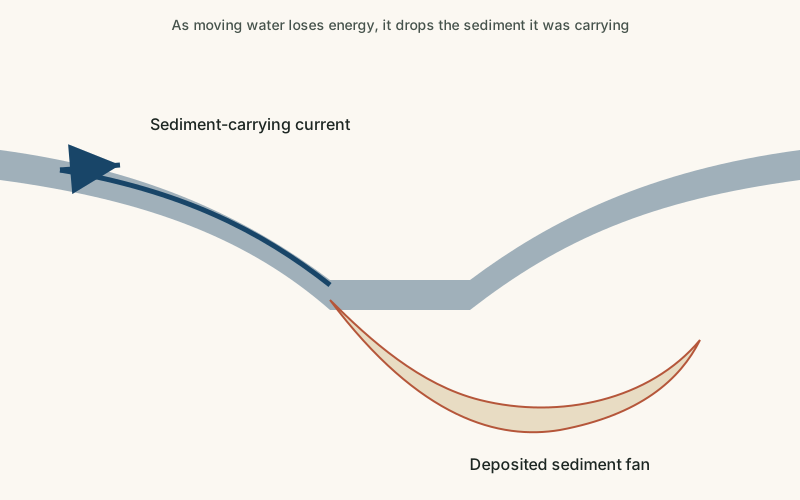
As a river flows across its drainage basin, it continuously picks up and carries sediment eroded from the land upstream, ranging from fine silt to coarser sand and gravel.
- The river slows as it meets standing water.
When the river reaches a sea, lake, or other body of relatively still water, its current loses the energy that was keeping sediment suspended, and it begins dropping its heaviest material first.
- Sediment accumulates and the channel splits.
As sediment builds up at the river's mouth, it often forces the channel to split into multiple smaller distributary channels, each depositing its own share of sediment.
- New land gradually extends outward.
Repeated deposition across many channels slowly builds new land outward into the water, layer by layer, sometimes advancing measurably over just a few decades in large river systems.
- Waves, tides, or vegetation reshape the result.
Depending on local conditions, ocean waves and tides may rework and redistribute the deposited sediment, while vegetation in calmer deltas can help stabilize new land and influence its final shape.
Formation Timescale
Large river deltas typically develop and shift their shape over hundreds to thousands of years, though individual channels and smaller features within a delta can change dramatically within a human lifetime, especially during major floods. Because the rate of land-building depends on sediment supply, which can be affected by both natural changes and human activity like dam construction, deltas are not uniform in how quickly they grow — some are actively expanding while others are currently shrinking as the balance between sediment deposit and natural erosion shifts.
Main Characteristics
- Branching distributary channels: a single river typically splits into multiple channels as it crosses its delta.
- Low, flat topography: deltas are built from fine sediment and sit only slightly above the water they empty into.
- Layered sediment deposits: delta sediment accumulates in distinctive layers that can record flood history and sea-level change.
- Highly fertile soil: repeated sediment deposition often makes delta land unusually productive for agriculture.
- Sensitivity to sediment supply: a delta's growth or shrinkage closely tracks how much sediment its river delivers over time.
Materials and Structures Involved
Delta sediment is sorted roughly by particle size and the energy of the water depositing it: coarser sand and gravel tend to settle closer to the river mouth, while fine silt and clay are carried further out before settling. Over time, this builds up layered deposits of sand, silt, and clay, often interspersed with organic material in slower, vegetated sections of the delta. In some deltas, particularly those formed in calmer water, decomposed plant material also contributes significantly to the buildup of soft, carbon-rich soil. Because deposition patterns shift as channels migrate across the delta over time, a single delta can contain a complex, interleaved mix of these sediment types at different depths.
Climates and Environments
Deltas occur in virtually every climate where a sizable river reaches standing water, from the tropical Ganges-Brahmaputra Delta to temperate deltas like the Mississippi's. The surrounding environment is almost always wet and low-lying, frequently supporting extensive wetlands, marshes, or mangrove forests that depend on the delta's mix of fresh water, sediment, and, in coastal deltas, some tidal saltwater influence. These environments tend to be ecologically rich but also highly sensitive to changes in water flow, sediment supply, and sea level.
Real Examples
The Mississippi River Delta in North America has been shifting its main depositional lobe for thousands of years and is currently losing land in many areas due to reduced sediment supply and rising relative sea level. The Nile Delta in Egypt has supported agriculture for thousands of years thanks to its naturally fertile, regularly replenished soil, though upstream dam construction has significantly reduced new sediment reaching it. The Ganges-Brahmaputra Delta, shared by Bangladesh and India, is one of the largest deltas in the world. The Okavango Delta in Botswana is an unusual inland delta that empties into a dry basin rather than the sea, creating a seasonal wetland in an otherwise arid region.
How It Continues to Change
Deltas are inherently unstable landforms, constantly gaining land in some areas through deposition while losing it elsewhere to erosion, subsidence, or rising sea levels. Many of the world's major deltas are currently losing land overall because upstream dams and levees trap sediment that would otherwise replenish the delta, while the delta's own weight causes its soft sediment to slowly compact and sink. Restoring natural sediment flow is a major focus of efforts to protect vulnerable delta regions, including coastal Louisiana.
Engineering projects in some deltas now attempt to deliberately redirect a portion of a river's sediment load back into areas that have been losing land, mimicking the natural deposition process that originally built the delta. The success of these efforts varies by location and depends heavily on how much sediment the river still carries after upstream modifications, which is part of why delta restoration is generally considered a long-term, ongoing effort rather than a one-time fix.
How It Differs From Similar Formations
Deltas are closely related to floodplains, but a floodplain is the low-lying land periodically flooded alongside a river's course inland, while a delta specifically forms where the river meets standing water and deposits sediment into it. Deltas also overlap significantly with wetlands, since many large deltas are themselves extensive wetland environments, though not all wetlands are deltas. Where ocean waves are strong relative to river sediment supply, the resulting coastline may show more wave-shaped features typical of general coastal processes rather than a clearly defined river delta.
Common Misconceptions
Misconception: All river deltas are triangular.
Reality: Delta shape depends on the balance between river sediment, wave action, and tides; many deltas are lobed, branching, or irregular rather than clearly triangular.
Misconception: Deltas are permanent, stable land once formed.
Reality: Deltas require continuous sediment supply to maintain their extent, and many are actively shrinking where that supply has been reduced by dams or other changes.
Misconception: A delta can only form where a river meets the ocean.
Reality: Deltas can also form where rivers enter lakes or even, in rare inland cases like the Okavango, a dry basin with no permanent outlet at all.
Key Terms
- Delta — A landform built where a river deposits sediment as it slows down and spreads out, typically where it meets a sea, lake, or ocean.
- Deposition — The process by which sediment carried by wind, water, or ice is laid down and accumulates in a new location.
- Sediment — Solid material — fragments of rock, mineral grains, or organic matter — that is transported and deposited by water, wind, or ice.
- Alluvium — Loose sediment — clay, silt, sand, or gravel — deposited by flowing water, typically in riverbeds, floodplains, and deltas.
- Tributary — A smaller stream or river that flows into a larger river rather than directly into a sea or lake.
- Drainage Basin — The area of land where all surface water, from rainfall to streams, drains to a common river or outlet.